Gran Canaria - "Hiking guide, Daytours, Sightseeing" |
 |
[Photobook Gran Canaria] [Photo catalogue] [Photocalendar] [Travelforum] [Travelreports around the world] |  |
Roque Nublo - The cloud rock monolithThe hiking to the plateau of the Roque Nublo monolith (see Map No. 13) is one of the most beautiful hikes in Gran Canaria and requires no mountaineering skills. The 80 m high, bizarre rock monolith is considered to be remnants of a prehistoric volcanic chimney.If you climb righthand on the stone high plateau of the rock monolith along via some boulders, you come to a very nice lookout point behind the rock monolith. The yawning depth at the cliff's edge and the views to Tejeda and Roque Bentayga are impressive. |  |
Caldera BandamaThe trailhead (about 3 hours) is the parking lot at Pico de Bandama (584 m) above Telde (see Map No 2). The surrounding on the crater rim offers breathtaking views of the sea and the crater ground 358 m below. On the crater ground we can see a farm with fields. | |
Playa de GüigüíTravel by rental car via Mogán towards San Nicolás. Turn to the left towards Tasartico on the second pass summit at the rest area "El Paso" (German host). Impressive views of the tomato growing areas of San Nicolás. After about 2.5 km keep left again and drive down into the valley to Tasartico. After the town link (in the town keep to the left) at a stake with shield park. Here is the starting point of the trail to the most beautiful beach of Gran Canaria (5 hours total for the round trip). In Barranco de Tasartico it goes through tomato fields downwards. After 750 m, the trail branches off to the right and climb up to the pass (547 m) steeply. Up to this point you need about 90 min., after a further 30 min. past a tiny hamlet inhabited you are at the desired goal, the black lava sand beach. A rock divides the Playa de Güigüí (time before the rising of the flood think of the way back) in two sections of the beach, where you can hike around the cliffs at low tide. | |
Round trip through the wild Cumbre (150 km)Von Maspalomas geht es im Ortsteil San Fernando unter der Autobahn hindurch auf der GC520 durch den Barranco Fataga zum Aussichtspunkt und Freilichtmuseum Mundo Aborigen.Danach kommt Fataga, eines der malerischsten Dörfer der südlichen Cumbre. In einem Palmental, am Ortsausgang von Fataga befindet sich das Hotel Molina del Agua, ehemals die Finca Cercado. In der Nähe kann man Dromedar-Reiten, ein Spaß für Kinder und Erwachsene gleichermaßen. | 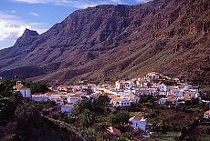 |
|
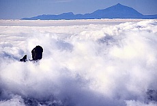
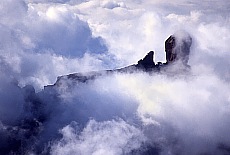
Über San Bartolomé de Tirajana geht es auf der C815 weiter nach Ayacata (Mandelbaumblüte im Februar) und dann rechts einige Serpentinen hinauf zum kleinen Parkplatz am Fuß des Roque Nublo. Hier beginnt die 1 Std. Wanderung zu dem grandiosen Felsmonolith (1813 m), dem Wahrzeichen Gran Canarias. Nächster Halt ist der Pico de las Nieves (1949 m), die "Schneespitze" und Gran Canarias höchster Berg. Ein Teil des Gipfels ist militärisches Sperrgebiet. Oft reichen die Passatwolken bis 1700 m Höhe und so schaut der Roque Nublo gerade noch aus der Wolkendecke heraus. Im Hintergrund ragt Teneriffa's mächtiger Teide (3718 m) aus dem Meer auf. Wenn man auf den Hexenkessel an Wolken hinunterblickt, glaubt man kaum, daß man vor 1 Std. noch auf dem Hochplateau des Roque Nublo gestanden hat. |
 |
 | |
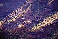
| Weiter geht's über das Cruz de Tejeda auf der C811 nach Tejeda. Schneeweisse Häuser, malerische enge Gassen, eine schöne Kirche und einen Panoramablick auf Artenara und den Roque Bentayga. Ein lohnender Abstecher führt rechts zum Roque Bentayga ein gewaltiger Basaltmonolith mit Höhlenwohnungen und Opferstätten. Über Ayacata geht die Fahrt vorbei an großen Stauseen hinunter nach Mogán. Vorsicht, der untere Teil der Strecke ist sehr steil und ungeteert, nichts für ängstliche Gemüter ! Auf der Hauptstraße C810 geht die Fahrt weiter nach Puerto de Mogán, einem künstlich angelegten Touristenzentrum im andalusisch-, holländischen Baustil - ideal für "Europapark Rust" Liebhaber. Vorbei an Retortenstädten wie Tauro und Puerto Rico geht's dann auf der C812 entlang einer wilden Steilküste. Das letzte Stück bis Maspalomas ist die Autobahn GC1. Wem das zu gefährlich ist oder bei schlechtem Wetter: Über San Bartolomé, Santa Lucia, Agüimes, dann zurück nach Maspalomas auf der Autobahn GC1. |
 |
 | |
Rund um die Insel (ca 250 km)Start in Maspalomas frühmorgens. Fahrt über Mogán Richtung San Nicolás.Nach einigen Serpentinen ragen farbige Tuff-Felswände, die Azulejos empor. Der Souvenir- und Erfrischungsstand läd zu einem kurzen Halt ein. Nach San Nicolás beginnt der wildeste Teil der Strecke. 400 m hoch und direkt über dem Meer liegt ein sehr schöner Aussichtspunkt in Richtung Teneriffa, der Mirador de Balcón. Nach El Risco kommen weitere spektakuläre Aussichtspunkte Cruz del Tabaibal und Cruz del Dionisio. Die Felsen fallen hier über 1000 m senkrecht ins Meer ab. Kurz vor Agaete hat man von der Küstenstrasse aus eine schöne Aussicht auf den Dedo de Dios, den "Finger Gottes", eine spektakuläre Felsformation. Im Hafen Puerto de las Nieves wartet die Olsen-Fähre nach Teneriffa. Nach einem Bummel durch Agaete führt ein Abstecher ins Valle de Agaete, ein Barranco mit subtropischer Vegetation. Weiter gehts auf der Küstenschnellstrasse 810 nach Las Palmas. Nach einem Stadtbummel und Bad an dem berühmten Strand Playa de las Canteras geht es in flotter Fahrt auf der Autobahn GC1 zurück nach Maspalomas. Round trip in the eastern part of the island Gran Canaria (about 150 km) |
 |
 | |
| Mirador Balcón de Zamora with a panoramic restaurant and magnificent view of the pilgrimage village Teror and the capital Las Palmas, Teror the religious center of Gran Canaria, the island patron statue saint Virgen del Pino from the 15th century, basilica in Gothic style from the 18th century, elaborate wooden balconies, Pico de Bandama, Caldera de Bandama, Telde, Agüimes, Cocodrilo Park |
 |
|
Still questions - then please join our Travelforum Gran Canaria | next page | |
Page is currently updated :-))
© made4you