| Hikingtips La Réunion |
 |
[Photos La Réunion] [Photo catalogue] [Photocalendar] [Travelforum] [Travelguides around the world] |
| Nearly at all hiking tours in the Cirques clouds often are drawing up after 12 o'clock noon. Therefore you should begin longer hiking trails very early at about 6 until 7 o'clock in the morning. The trails are marked and signed very well, so that you don't need high-precision Map of trails. |
Cirque de Mafate | |
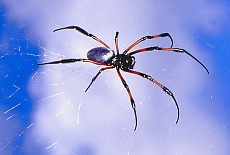
Cap NoirThe Cap Noir enables us a very good Lookout into Cirque de Mafate. Easy approach over Dos d'Ane to the parking area near Cap Noir, then further on the easy accessible footpath in circa 1/2 hour.Interesting are the big Silk spider overall along the narrow trail :o)) |
 |
Roche Ecrite (2277 m)Directing from St. Denis via le Brûlé to the parking and rest area Mamode Camp (1200 m). Possibly overnight stay in the Gîte (1840 m) at the edge of the Plaine des Chicots (Reservation necessary). From the parking to the Gîte ca 21/2 hours hicking and continue to the summit of the Roche Ecrite again ca 11/2 hour.One of the island's most scenic vantage points opens breathtaking views into the Cirques de Mafate and Salazie. |
Piton Maïdo (2190 m)From the parking lot near the summit of Piton Maïdo we walk along the mountain line with breathtaking views into the Cirque de Mafate and to the highest mountain of La Réunion Piton des Neiges. Summit Le Grand Bénare (2896 m)From parking area at Piton Maïdo you follow the sign for Grand Bénare (white marker). Passing the Caverne de la Glacière we reach the summit of Grand Bénare in about 31/2 hours (800 m altitude difference).The view into the yawning depths of the Cirque de Mafate is indeed magnificent, but that was the Piton Maïdo already so and without any physical exertion :o)) For the way back you need about 2 hours. L'Entre-Deux, Aufstieg zum DimitileMit 4WD-Geländewagen kann man sich bis knapp unter den Gipfel des Dimitile (1837 m) hinauffahren lassen. Dann an der Abbruchkante entlang möglichst weit Richtung Sommet de L'Entre-Deux (2350 m) wandern. |
 |
 |
|
The ridge path is one of the most beautiful panoramic paths of La Réunion: Lefthand the yawning depth of Cirque de Cilaos, right side the Plaine des Cafres with the volcano Piton de la Fournaise, straight on the highest Mountain of La Réunion the Piton des Neiges. The last part of the trail to Sommet de L'Entre-Deux requires a head for heights (climbing ladders). Hiking time approx. 4 hours. Cirque de CilaosRoche MerveilleuseLookout rocks with a beautiful view downto Cilaos, starting from the road to Bras Sec. There is a botanical trail here (1 hour.).Waterfall Cascade de Bras RougeAt the Maison de la Montage between the restaurant Les Sentiers and the hotel Le Petit Randonneur, descend the path of the porters to the old spa house. After the 2nd bridge there is a slope and the trail starts in the first bend (approx. 21/2 hours round trip).With a couple of luck you can watch the waterfall climbers doing their breakneck work. Col du Taïbit (2083 m)The hike starts on the road to Ilet à Cordes (D 242) at milestone 5 (whatch signpost) or directly in Cilaos past the waterfall Cascade de Bras Rouge. Steep, well-developed main hiking trail (GR 1, approx. 3 hours ascent through tamarind forests, 2 hours back, 850 meters altitude difference). Schöne Aussicht in die Cirques de Mafate und Cilaos und auf Les Trois Salazes (Felsnadeln). Vom Col du Taïbit führt der Weg zuerst durch einen Wald von Mimosabäumen und dann in Serpentinen steil hinunter in den Cirque de Mafate nach Marla.Piton des Neiges (3069 m)Start am Parkplatz Le Bloc auf der Strasse Richtung Bras Sec. Aufstieg zur Berghütte Caverne Dufour (2478 m, ca 1200 Höhenmeter, vorher unbedingt einen Platz für die Nacht reservieren). Am nächsten Morgen sehr früh (spätestens um 4 Uhr) aufbrechen (ca 600 Höhenmeter), um den grandiosen Sonnenaufgang auf dem Gipfel zu erleben.Auf dem gleichen Weg zurück oder Abstieg nach Hell-Bourg. |     |
Cirque de Salazie | |
Roche Ecrite (2277 m)Behind Grand Ilet, the very steep and sometimes slippery path (approx. 1100 vertical meters) starts to one of the most beautiful mountain ranges of La Réunion.Too dangerous and too exhausting :o(( La Nouvelle im Cirque de MafateAnfahrt über Grand Ilet und Le Belier (1550m). Der steile Aufstieg zum Col de Fourche (1942m) wird belohnt mit einem atemberaubenden Einblick in den Cirque de Mafate. Von La Nouvelle aus über die Plaine de Tamarins wieder zurück zum Ausgangspunkt (ca 7 Std. Gesamtgehzeit). |  |
Forêt de BélouveVon Hell-Bourg hinauf zur Gîte de Bélouve (ca 2 Std., 580 Höhenmeter) mit atemberaubendem Blick in den Cirque de Salazie.Then further on to the lookout above the Trou de Fer (Höllenloch, 1 1/2 hours, 120 Höhenmeter). |  |
Volcano area | |
 |
 |
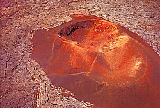
Bei der Anfahrt über die Plaine des Cafres mit ihren sanften Hügeln, grünen Wiesen und Kühen kann man kaum glauben, dass ein paar Kilometer weiter so eine brutale Lavawüste wie die Plaine des Sables folgt. Grösser kann der Kontrast nicht sein.Piton de la Fournaise (2631 m)Übernachtung in der Gîte du Volcan am Pas de Bellecombe. Vom Parkplatz führt der Weg zunächst am Kraterrand entlang,dann durch eine massive Eisentür 100 m steil hinunter in den Enclos Fouqué (Kratergrund) vorbei am Formica Léo.Ist die Eisentür verschlossen oder herrscht dichter Nebel, dann nimmt die Wanderung bereits hier ein jähes Ende :o(( | 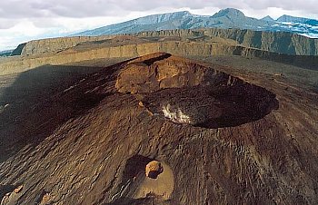
|
| Since the big volcanic eruption of the Piton Fournaise in April 2007, the hike around the two large craters Bory and Dolomieu is too dangerous, as the Bory crater has collapsed. Alternatively, take a hike on the right past the craters Bory and Dolomieu to Cratere Rivals. A descent into the caldera of the crater with its colorful rocks is recommended. | |
Morne Langevin (2403 m)Der Rundweg (im Uhrzeigersinn gehen, 3-4 Std.) beginnt am Parkplatz, bevor die Strasse in Serpentinen zur Plaine des Sables hinunterführt. Man meint tatsächlich, daß die Lava aus der schwarzen Ebene 2000 m tief in den Talkessel Rivière Langevin hinabfließt. Die Tour lohnt sich nur bei klarer Sicht. |  |
Hiking in the Rainforest | |
Forêt de BébourIn La Plaine des Palmistes beginnt die 18 km lange Forststrasse (RF 2) in den Forêt de Bébour.Etwa nach der halben Fahrstrecke gibt es einen Lehrpfad am Col de Bébour (ca 1 1/2 Std.). Die Forststrasse endet bei der Gîte de Bélouve. At the top of the rock fall to the Cirque de Salazie offers a breathtaking view, then we walk on to the Trou de Fer (hell rock hole, 1 1/2 hours, 120 meters in altitude). | |
Mountain and Alpine huts (Gîtes) on La Réunion:
|  Le Gîte du Volcan Pas de Bellecombe 30 rue Bory St. Vincent 97 418 Plaine des Cafres Tel: 0262/51 17 42, Fax: 0262/51 18 29 |
|
Still Questions - then please visit our Travelforum La Réunion | next Page |
© made4you